A short trip to the heart of world orienteering
Hoias Night Training
Jon Musgrave recently paid a visit to Halden to catch up with the Norwegian section of Maroc (elite athlete Helen Palmer) and to find out what new developments are going on in a top international club. Read on to hear what he found.
Various factors combined to make a trip to Halden into reality this winter and so I took the Ryanair flight from Edinburgh to “Oslo” – well Rygge which is an hour south of Oslo but, more importantly, only about 45 minutes by car from Halden.
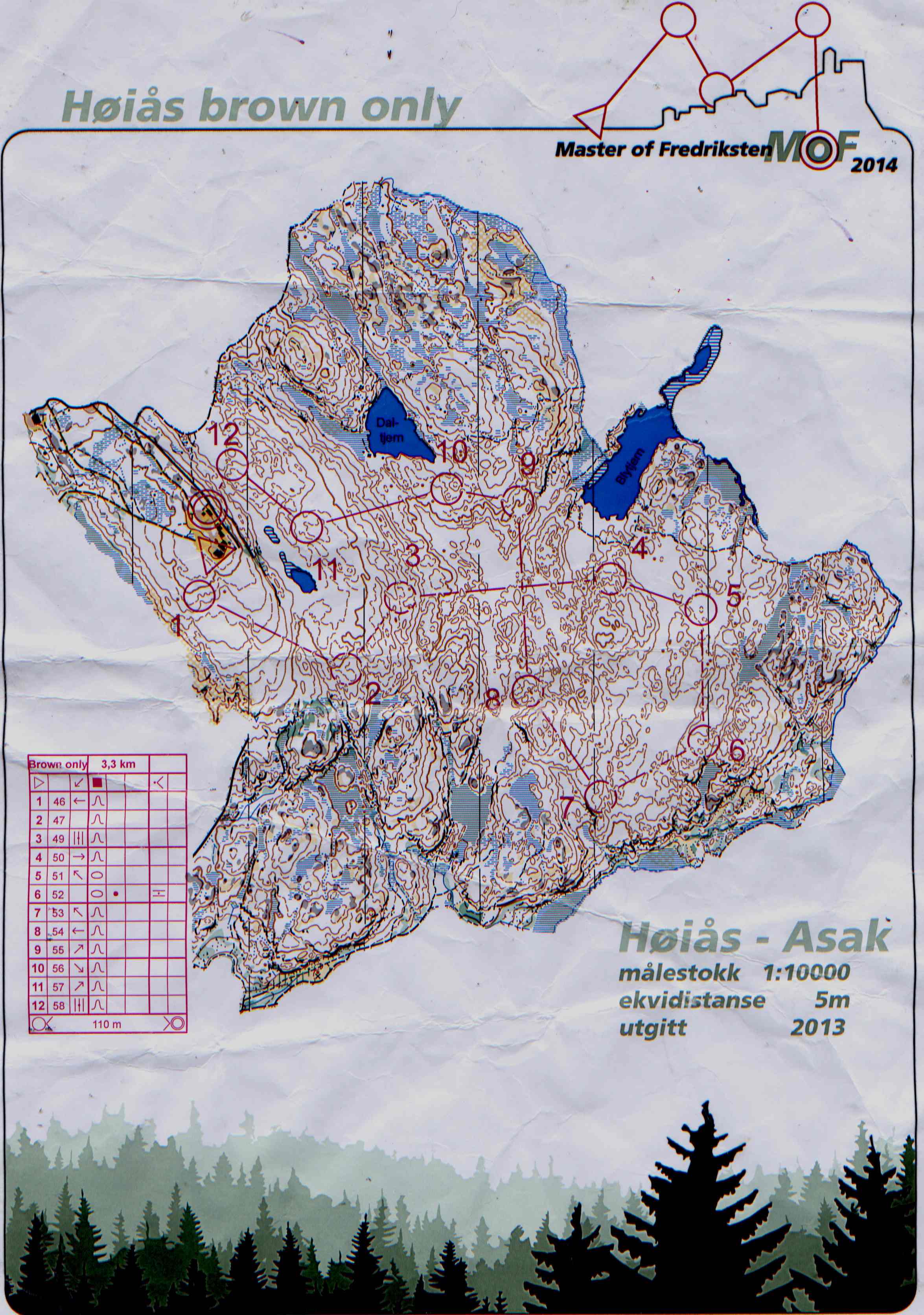
Helen Palmer drove me straight to the heart of the heart in orienteering terms – Hoias where there was a night-O course set out (one of 12-15 that are out this winter in the forests round Halden). But not just a night-O course, a contour-only night-O course…. See the scan below. Helen mentioned that the best time for the course at night was 30 minutes – so I decided anything below 40 minutes would be a success (actually just getting round the course would be a success….). It was a freezing cold night – a little sprinkle of snow here and there…. and very dark in the forest, but I set off up the track to the start, a decent warm-up to get my mind settled and into focus.
I reached the huts and recognised the familiar shape of Hoias hytte from many trips here over the years (first visit in summer 1981….). I was telling myself to use my compass and take my time. The first control worked nicely – dropping slightly across the rock slabs and then turned left down the re-entrant and the flash of the reflector confirmed that I was on the correct line. 1-2, kept left of the line, crossed the main track and dropped down the steep slope just to the left of a crag, turned right to follow the edge of the slope, then keeping the flat area to my right, felt I had gone far enough and on checking the map realised the control was on opposite slope, so turned left, over slight rise and again saw the reassuring flash of reflector. 2-3 Compass across first re-entrant, pushed slightly left by bushes and so when I hit the second reentrant turned right and dropped over other side, reflector, nice! 3-4 Longer leg, break it down, flat areas are probably marshes – and so it turned out, wet, cold open marshes. Not 100% sure of position on leaving the marsh, but reckoned it was left of the line. Met an steep slope, followed it to the right and saw the small hill above the form-line, over the gap and across the reentrants, into step sided narrow reentrant and realised the control was a little further on and flash – reflector exactly where I expected it. 4-5 Tricky, diagonally across the slope onto flat area – low visibility younger trees, so careful on compass, over hill, checked shape – it was the U shaped one, spotted next big hill and compass onto small hill, control visible from a fair way off. 5-6, Compass over small bobbly hills and then met a steep slope facing me – checked map and realised that I had expected a slope down but it was up, followed this along to a little kink then climbed onto flat top. There seemed to be a hill to my right, but everything else fitted so I carried on and saw the flash. 6-7, getting confident now. Compass off ridge onto flater ground, crossed various small lumps, didn’t try to check exactly which and then crossed a pointy ended spur – carried on and into reentrant, thought I was to the left of the control so turned right up the reentrant, no control, checked map – I must be to the right so turned left and ran along the slope, nothing. Checked map and decided to bail out to steep slope beyond control and to try to pick up here - crag wasn’t obvious so I must be to the right still, turned left, checked compass and flash, the reflector blinked! 7-8 Compass up slope, onto little edge to hill top and then cut to right through gap between hills, saw relector from 60m or so – further left than I expected, but I was struggling to interpret the map (dodgy eyes!). 8-9, Compass to north, past a sharp craggy ended hill – probably where contour and form line touched, then into a marsh – too far left, must have drifted/been forced by the terrain. Turned right and tried to keep to higher ground as the marshes were slow and cold! Kept marsh to my left and followed line till ground dropped and ahead of me I saw a big slope – the large lump where the control was located, up slope and read knolls into control. 9-10, compass diagonally across slope past crag above reentrant and up to hill top, aimed to left of high point and control appeared just where it was expected. 10-11, up big hill, passed linear dot knoll on slope, good check, up till slope levelled off and then head up, picked up slight rise of the form line hill and straight into the control. 11-12compass, past hill, across reentrant to my left and onto second hill, kept edge to my immediate left and ran on top till little niche appeared in front of me, turned left and the control appeared in the little niche below me. 12-F, Hard up hill, (using a rope across an icy slab at one point), turned left and ran to buildings. Done, checked watch 38-25, pretty satisfied with that, one error (7) and a few wobbles and hesitations.
Sunday 30th, Hoias Day Cup race at Idefjordfjella. I was entered on the Medium course – 8.2km but with the added bonus of a timed hill run to the start point – 1.3km and 145m climb – for bonus points in the Cup series, I didn’t win this!
A real bonus of this event was that everyone was given a GPS tracker, a first for me, and it certainly added to the pressure and excitement, the GPS is uploaded instantly so anyone watching on the web can see my mistakes before I even know I’m making them…. Anyway I ran steadily on the course, tiring over the last 2 long legs, but was pleased to be only 10 minutes behind Kjetil Bjorlo an old adversary from World Cup races many years ago (my excuse was that he was in “quite good shape” and had local knowledge). From the GPS tracking it was apparent that I mostly took sensible routes, but lost time on 5-6 by climbing too much – should have gone right of the line through the gap in the hills. Anyway a decent run, no major mistakes and confident of my position the whole way. It certainly opened my eyes to the benefit of the tracking systems…. Maybe Maroc can buy some for junior training and races.
Check out the tracking at:
https://events.loggator.com/2014HDNC4h
click on the “2drerun” button at top right and start playing with it!
Monday morning Helen and I checked out a Swedish forest (relevant to WOC 2016) just across the border then in the evening I went to the Halden Ski Club strength training session – wait till I lead an indoor session and can show some of the exercises……if I haven’t blanked them from my mind by then
Tuesday morning was taken up by a run round the Fredricksten Festning, Haldens great fortress, which was very pleasant and scenic. Return was a 2pm train to Rygge, a free bus to the airport (5 minutes away) and then a boring flight back to Edinburgh.
Overall a fantastic experience of visiting one of the greatest clubs in the orienteering world and having the privilege of training with their top runners.
Jon Musgrave