Sluie Regional Event
Incorporating a Jon Duncan Junior Deeside Trophy (JD2) race
Sun 16th Mar 2025
Type of event: Regional Race, JD2C
Type of terrain: Forest
Info updated: 17th Mar
Results
A Regional Event for all abilities with a full suite of Colour-coded courses for all abilities from White to Brown. This is a British Orienteering Ranking Event.
Location

Nearest town: Potarch
- Grid Ref: NO606971
- Postcode: AB31 4BE
- Lat/Lon: 57.06395,-2.65053
- Google Map
- Streetmap (OS)
- Bing Map (OS)
- OpenStreetMap
Pre Event Info
A Regional Event for all abilities with a full suite of Colour-coded courses for all abilities from White to Brown. This is a British Orienteering Ranking Event.
Grid reference - NO606971. What3words - skim.trailing.moped
COVID19: People suffering from Covid or isolating must not attend events or activities to protect others.
Directions / Parking
Car parking will be in the Potarch public car park located just off the B993 south of the Potarch Bridge. Parking space is limited, overflow will be along the roadside between the car park entrance and the junction with the café.
Registration & Start Times
Registration: 10:45 – 12:30
Start: 11:00 – 13:00
Course close: 15:00
Registration will be in the public field next to the car park.
There will be no allocated start times. Punching start and finish.
Everyone must report to the finish and proceed to Download, whether they finish their courses or not. Otherwise, you may trigger a search party and/or call to the emergency services.
Course Information
There are two starts, one for the White, Yellow and Orange courses, and one for the Light Green, Green, Blue and Brown courses.
White/Yellow/Orange Start: 570m from registration.
Light Green/Green/Blue/Brown Start: 450m from registration.
Finish: 400m to download.
The route to the starts and from the finish involves a number of road crossings and using a bridge which has no pavement. Please follow the taped route carefully and follow all instructions given by the crossing marshals. There is a mandatory crossing for the A93 both out and return. When going across the Potarch bridge, please walk single file on the west side of the bridge as the bridge will also be used by vehicles.
The terrain is a wooded hillside with plenty of rock detail immediately north of Potarch bridge.
A regional event with Brown, Blue, Green, Light Green, Orange, Yellow and White courses.
| Colour code | Length, km | Climb, m |
| White | 1.6 km | 50 m |
| Yellow | 2.1 km | 55 m |
| Orange | 2.7 km | 70 m |
| Light Green | 3.4 km | 135 m |
| Green | 4.4 km | 210 m |
| Blue | 6.2 km | 275 m |
| Brown | 8.4 km | 315 m |
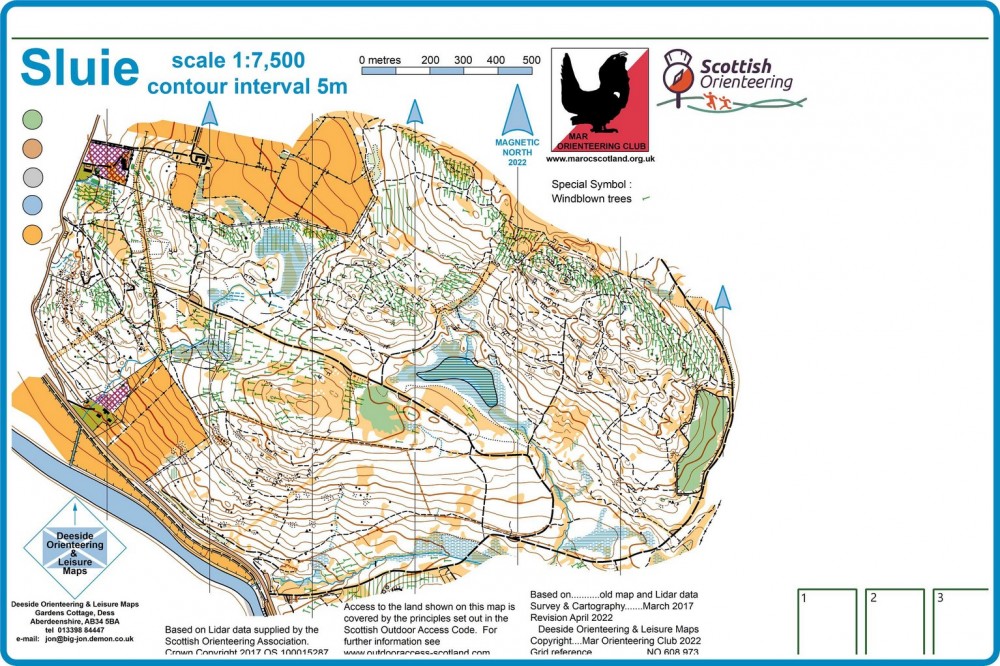
The map scale is 1:10,000 for courses from Orange and longer. The Brown course involves a map-flip. Loose control descriptions will be available for Orange and longer courses. 1:7500 scale for White and Yellow. The map was updated in 2022 with a recent revision for windblown trees. Much of the windblown has been extracted, and the forest is very runnable. The area is also used by an off-road 4x4 driving club and a Motocross motorcycle club. It is not possible to keep up with the new tracks which these activities create, so there are some tracks in the area which are unmapped. These tend to be new, and fairly rutted, and the courses have been planned to avoid them as much as possible. There are also some tapes and triangular orange flags in the forest related to these other activities.
SportIdent (SI) electronic timing will be used, with SI Air enabled. If you have your own SI dibber, please bring it. Otherwise, SI dibbers can be hired for £1, but with £30 charge if lost.
Explanation of colour courses
- White are very easy with all controls on paths. They are mainly used by 6-10 year olds and family groups.
- Yellow use simple linear features like paths, walls and streams. They are mainly used by under 12’s and family groups.
- Orange progress to basic use of the compass and route choice. They are ideal for novice adults or experienced youngsters.
- Light Green are ideal for improvers as the navigational difficulty begins to increase and uses simple contours and point features.
- Green are used mostly by experienced under 18’s and adults wanting a short but challenging course with a very hard navigational difficulty.
- Blue are a longer, more physically demanding course in comparison to the green. The distances are more varied between controls and the course attracts experienced orienteers.
- Brown & Black are very physically demanding and have a very hard navigational difficulty. They are for experienced orienteers only.
- Score means visiting as many controls as possible in any order in a specific time, like 45mins.
Entry Details
Entry is via Fabian4 HERE
Online entries close on the 9/3/25. There will be limited entry on the day, so please register in advance to guarantee a map.
Entry fees: Seniors £10, Juniors £5
SI dibbers can be hired for £1, but with £30 charge if lost.
Facilities
There are public toilets in the car park.
There is a very nice café next to Potarch bridge for drinks and food, details HERE.
Dogs allowed?
Dogs are welcome as long as they are kept under control and dog poo picked up.
Contacts / Officials
Planner: Alan Bennett
Organiser: Paul Mather
Controller: Paul Duley
Info about the area
Wooded hillside with plenty of rock detail immediately north of Potarch bridge.
Safety and Risk
A comprehensive risk assessment will have been carried out by the organiser, but participants take part at their own risk and are responsible for their own safety during the event.
This includes dressing appropriately for the weather conditions, and carrying a whistle.
Participants in orienteering should be aware of the risk of tick bites - more information here.
SPORTident timing will be used
Please note that a lost hire SI-Card will be charged for at a rate of £30, unless the Club Commitee agrees that there are special circumstances.
Privacy
When entering our events your name may appear in the results section of this website or in newspaper reports.
Read our privacy policy to see how we look after your personal data.