Balfour National Event (SOL 2)
2024 Scottish Orienteering League #2
Sun 21st Apr 2024
Type of event: National Race, JD2C
Type of terrain: Forest
Info updated: 22nd Apr
Results
Welcome to Spring in Classic Orienteering terrain on Royal Deeside for the second 2024 Scottish Orienteering League Event.
Start lists are available on SI Entries here.
Balfour is on the southern slopes of Deeside, 3km SE of Aboyne, a large forest, last used for a National status event on Day 2 of Royal Deeside 2017.
This event is held as Day 2 of a Double-header weekend with Tayside Orienteer's Scottish Middle Distance Championships at Alyth Hill on Saturday 20th April.
Follow the old drove roads across the Mounth for our SOL 2 event at Balfour on the Sunday.
Location

Nearest town: Aboyne
- Grid Ref: NO543962
- Postcode: AB34 5DB
- Lat/Lon: 57.05531,-2.74853
- Google Map
- Streetmap (OS)
- Bing Map (OS)
- OpenStreetMap
Pre Event Info
The Course v Age Class matrix for the Scottish Orienteering League has been updated for 2024. This year you and your age class may be running a different course!
IMPORTANT NOTES
The main bridge over the River Dee at Aboyne is closed to all but pedestrians and cyclists. If you are coming from the North or West you will need to cross the river at Dinnet or Potarch, and use the South Deeside Road.
Please bring £5 cash for parking. This will be collected at the entrance to the parking field. We regret that this charge is necessary. Strenuous efforts were made to find somewhere cheaper, but it came down to this or nothing.
Planner’s Notes for competitors:
Balfour Woods is fairly new to orienteering having been used during S6D Deeside in 2017.
Much of the wooded area is white, so other than some pockets of storm damage from two years ago, mostly runnable for strong runners. There are plenty of brashings, fallen branches, mossy boulders etc. There is one large, and two small, open areas; the largest area (in the middle of the map) is only used by the longer technical courses and very briefly by the Very Short Green. The areas mapped as rough open are generally hard going.
- Last used for a major event at the Scottish 6-Days in 2017.
- There are a few deer tracks in the area which tend to contour. Major rides and forestry vehicle tracks are mapped as rides. However, there are many minor forestry vehicle tracks and extraction lanes (mostly up/down slopes) which are not mapped.
- There are many MTB tracks, all of which are mapped, and used for the majority of the TD1, 2 & 3 courses. We have asked the MTB community to ride elsewhere on the day of this event, so hopefully no riders on these tracks during your run.
- The courses have been planned to avoid the worst of the storm damage from two years ago. Where there is a significant amount of storm damage, this has been mapped accordingly. Some legs pass through storm damaged areas but these tend to only be lightly damaged areas. A couple of severely damaged areas around the large open/felled areas is mapped as fight (i.e. dark green).
- Bracken areas have been mapped for route choice, not fine navigation.
- Some of the longer courses cross a number of walls and fences – please take care when crossing these and report any damage.
Directions / Parking
Follow the B976 (South Deeside Road), either 8km eastwards from Dinnet, or the B993/976 10km westwards from Potarch, until you reach the west end of the minor road signposted to Birse and from where there will be event signage. This turning is between houses on the edge of Aboyne, has limited visibility and is frequented by walkers and cyclists – take care.
Car parking will be after 2.5km in a field off the minor Birse road. Access will be from the Aboyne end of the road only. Please do not come from the East end of the road.
As above, we will be collecting £5 per vehicle at the entrance to the field. Please have cash ready. An alternative which we would encourage, would be to park in Aboyne and cycle 3km to the event. If parking in Aboyne, please park courteously and do not add to congestion by parking near the Boat Inn beside the bridge – there is plenty of space in the village centre.
OS Grid Ref: NO 543 963
Latitude: 57.0548750 N, Longitude: -2.7542842 W
What3words: self.stacks.towel
Please do not use a postcode for navigation as it covers a large area.
Camper vans: These will be permitted in the parking field.
Arrival/departure times: Departure from the event will be by the same route as arrival. Please arrive at the event by 12.30. It will not be possibly to leave the event until after 12.30.
Registration & Start Times
Entries are closed Start lists are available on SI Entries here.
Registration will be open from 10.00. There will be some limited entry on the day subject to map availability. Payment by cash or card. Also collection of hired dibbers, white and yellow maps, car key drop and general help for anyone new.
Start times for the SOL are between 11:00 and 13:00 and will be available on SI Entries and on a link from the MAROC website. There will be no changes to start times on the day. If there are any issues/queries prior to the event, please contact the organiser on .
Timing: SI electronic timing, with SI Air (SIAC) enabled, will be used. Start times have been allocated but a punching start will be used. Everyone must punch both the Start and Finish SI Units even if using SI Air. Where SI dibbers hire has been requested these must be collected at Enquiries in the car park field. They will be in an envelope with your name on the front.
Course Closure: Courses close at 15:30. Please ensure you have returned and visited Download by this time.
Poor Weather: Should the weather be very cold and wet, waterproof jackets may be made compulsory. This will be intimated by a sign at the car park exit. It is recommended that all competitors carry a whistle.
Map Scale used is 1:10,000.
Results: there will be live online results available, but no other results display in the car park. https://www.marocscotland.org.uk/latest-results/. It will be subject to the vagaries of mobile reception in the area.
Course Information
White and Yellow maps must be collected from Registration in the car park field before proceeding to the start.
Course details and new age class/course information in the table below.
|
Course |
Age classes |
Length, km |
Climb, m |
Start |
|||
| Junior | Adult | ||||||
| Men | Women | Men | Women | ||||
| Black | M21 | M-E | 10.9 | 320 | Far | ||
| Brown | M20 |
M35 M40 |
W-E W21 |
9.1 | 260 | Far | |
| Short Brown | M18 | W20 |
M45 M50 M21S |
W35 | 7.6 | 215 | Far |
| Blue |
M16 M20S |
W18 |
M55 M60 M35S M40S |
W40 W45 W21S |
6.3 | 150 | Far |
| Short Blue | M18S |
W16 W20S |
M65 M70 M45S M50S M55S |
W50 W55 W35S |
5.0 | 85 | Far |
| Green | M16S |
W16S W18S |
M75 M60S |
W60 W65 W40S W45S |
4.4 | 70 | Far |
| Short Green |
M80 M65S |
W70 W50S W55S |
3.7 | 70 | Far | ||
|
Very Short Green |
M85 M90 M70S M75S |
W75 W80 W85 W90 W60S W65S W70S |
3.2 | 75 | Nearer | ||
| Light Green | M14 M16B |
W14 W16B |
3.5 | 80 | Nearer | ||
| Long Orange | M21N | 5.4 | 170 | Nearer | |||
| Orange | M12 M14B |
W12 W14B |
2.9 | 35 | Nearer | ||
| Yellow | M10 M12B |
W10 W12B |
2.3 | 15 | Nearer | ||
| White | M10B | W10B | 1.6 | 0 | Nearer | ||
String Course: There will be one. It will be a two-minute walk from the car park, though will involve walking on the minor road for a very short distance.
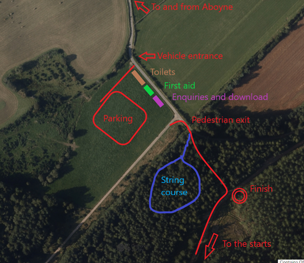
Starts:
There are two starts. Please refer to the table above to find out which start is yours.
The Nearer Start is 1.9km (140m steady climb) from the corner of the parking field, with the Far Start being 2.4km (same elevation as Nearer Start) from the same corner of the field. The Far Start passes the Nearer Start, then another 500m. The route to the Starts is 100m on a very minor road, 100m on a small path, then the rest is on a wide, good quality wide forest track, although we will need to keep off this wide forest track initially to avoid the run in to the finish. Allow 30 minutes to walk to the Nearer Start and 35 minutes to the Far Start.
Call up for the start will be at -4 minutes. Control descriptions will be available in the start lanes.
If you are late for your start time, please report to the start official. It may take some time to fit you in depending on the number of starters on each course.
Finish: The finish is 200m from the car park. Please proceed to the car parking field to download.
Explanation of colour courses
- White are very easy with all controls on paths. They are mainly used by 6-10 year olds and family groups.
- Yellow use simple linear features like paths, walls and streams. They are mainly used by under 12’s and family groups.
- Orange progress to basic use of the compass and route choice. They are ideal for novice adults or experienced youngsters.
- Light Green are ideal for improvers as the navigational difficulty begins to increase and uses simple contours and point features.
- Green are used mostly by experienced under 18’s and adults wanting a short but challenging course with a very hard navigational difficulty.
- Blue are a longer, more physically demanding course in comparison to the green. The distances are more varied between controls and the course attracts experienced orienteers.
- Brown & Black are very physically demanding and have a very hard navigational difficulty. They are for experienced orienteers only.
- Score means visiting as many controls as possible in any order in a specific time, like 45mins.
Entry Details
Entry fees are £18 senior and £9 junior. The reduced rate applies to all runners on courses up to light green. There is a £2 surcharge for seniors who are not members of British Orienteering. This is because there is an additional insurance fee for those who are not BO members. Note that there is a gently climbing walk to one of 2 starts of about 30 -40 minutes.
This event is suitable for beginners, with help on hand to get you started. If unsure which course to enter, please contact the organiser at . There will be some limited entry on the day subject to map availability.
Facilities
There will be 3 toilet cubicles in the parking field. There will be no others. There are also Public Toilets in Aboyne.
First Aid: First Aid will be available in the parking field.
Key drop: Car keys can be left at enquiries.
Water: There will no drinking water available at the event.
Traders & Catering: ScotJOS will have a cake stall. Please bring cash.
Ticks: Ticks are present in the area. Please remove any you find, as soon as possible. More information can be found here: https://www.publichealthscotland.scot/our-areas-of-work/health-protection/infectious-diseases/lyme-disease/overview/ . Please take the threat seriously.
Safety: Competitors take part at their own risk and are responsible for their own safety.
Dogs allowed?
Dogs: Dogs on leads are permitted in the parking field. Please clean up after your dog straight away.
Area usage by others: Balfour has become a popular mountain biking destination. The MTB community know about the event, and have been discouraged from using the area on the day. You may still encounter bikers and walkers, so please be courteous.
Contacts / Officials
Organising Team Leader: Sue Barrie
Planners: Andrew McMurtrie and Alan Bennett
Controller: Ian Hamilton (GRAMP)
Maroc are grateful to the following who have permitted the event to go ahead:
Land Owners:
- Birse Community Trust
- Ballogie Estate
- The Cochran Family
- Dunecht Estate
- Parking field: Philip McConnach
Info about the area
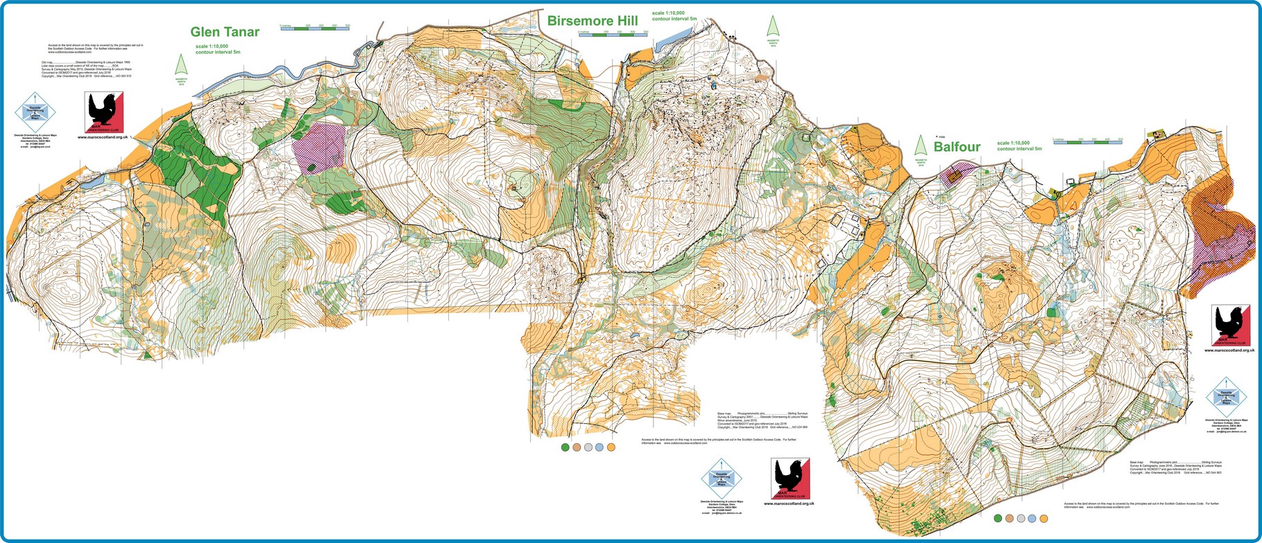
Glen Tanar, Birsemore Hill and Balfour maps in one large map.
More details about Balfour Large
Safety and Risk
A comprehensive risk assessment will have been carried out by the organiser, but participants take part at their own risk and are responsible for their own safety during the event.
This includes dressing appropriately for the weather conditions, and carrying a whistle.
Participants in orienteering should be aware of the risk of tick bites - more information here.
SPORTident timing will be used
Please note that a lost hire SI-Card will be charged for at a rate of £30, unless the Club Commitee agrees that there are special circumstances.
Privacy
When entering our events your name may appear in the results section of this website or in newspaper reports.
Read our privacy policy to see how we look after your personal data.