Linn of Dee POC
Near: Braemar scotland
Terrain
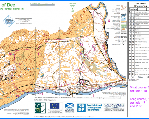
The Permanent Orienteering course at Linn of Dee has been designed to give you an opportunity to explore some stunning highland scenery whilst at the same time practising your navigational skills. The course is ideal for families and groups and offers two levels of length and difficulty.
Location
Nearest town: Braemar scotland
- Grid Ref: NO062898
- Postcode:
- Latitude: 56.98960
- Longitude: -3.54330
- Google Map
- Streetmap (OS)
- Bing Map (OS)
- OpenStreetMap
Parking for the Linn of Dee course is at the NTS car park (chages apply, members free) at Linn of Dee. Follow signs from the A93 in Braemar. You will find the start point just across the road from the entrance to the car park, where there is a post with a small orienteering marker plate. The finish point is located at the information point within the car park area. Printed copies of the map may also be available here.
Short Course – around 2.5km with a small amount of climb. The course is all on paths / tracks and offers a simple navigational challenge. You should visit control points 1-10 in that order.
Long Course – around 5.0km with 150m of climb. The course follows the short course initially, but then heads through some rougher off-track terrain, including deep heather and rocky ground in places. The navigational challenge is relatively simple but you will need to be confident enough to go cross-country. You should visit control points 1-7 and then 11-21 in that order.
The course all lies within the NTS Mar Lodge Estate. Many thanks to them for permitting access. Please respect the sensitive nature of the area by sticking to the planned route. You can find out more about visiting the Mar Lodge Estate here.
A limited stock of printed maps should be available from the information area at the Linn of Dee car park.
