British Night Championships 2019
Muir of Dinnet
Sat 23rd Feb 2019
Type of event: Major Race, Night
Type of terrain: Forest
Info updated: 01st Mar
Results
Results Explanation 01/03/2019
Muir of Dinnet, Aboyne
Event centre – Dinnet Village Hall, GR NO 459 987
START LISTS NOW PUBLISHED minor revisions 22/02/2019
Location

Nearest town: Dinnet
- Grid Ref:
- Postcode: AB34 5JY
- Lat/Lon: 57.07669,-2.89305
- Google Map
- Streetmap (OS)
- Bing Map (OS)
- OpenStreetMap
Pre Event Info
Final notes (19th Feb 2019)
1 – Dangerous crags along Burn O’Vat gorge will be taped using Black and Yellow tape. This will be done on all large crags on the north side and large crags on south side near control sites.
2 – Recent forest work (thinning) – the affected areas will be marked on maps in the start lanes and at registration in village hall.
3 – The weather forecast is for dry, mild and fairly settled conditions, however please still ensure you have adequate clothing to cope with February in Deeside. Remember your spare head-torch and whistle.
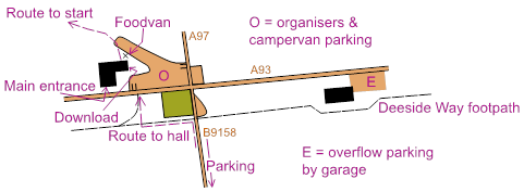
4 – Entries are now approximately 300 so later arrivals may need to use the overflow parking in the garage forecourt to the east of the village hall. From here cross A93 to the north side and follow the large pavement along to west to the hall.
5 – Pizza van confirmed for purchase of food at the hall and CompassPoint will also be in attendance (for buying the spare torch and whistle?).
6 – The first aid team (thanks to F1 Training Services) will be based in a tent at the pre-start area. All competitors will pass this twice - before they start and after they finish. Please seek help here if you have any injuries. There will also be a small first aid kit at the Village hall for very minor issues.
7 – Course closing time is 2220.
Directions / Parking
Please do not arrive before 1800.
Parking, along B9158 from cross roads to bridge, please approach from the A93 and leave across the Dee bridge and B976 South Deeside Road. Parking MUST be on tarmac not verge (estate stipulation). GR NO 459 987 to 462 982. Event helpers will be marshalling the parking, please obey instructions. Large vehicles (campervans etc) will park in the hall carpark – access from A97 to north of cross roads.
House holders on the B9158 have been informed and we must keep access open to their driveways. Overflow parking has been agreed with Dinnet Motors, 300m to the east of the junction. Cross A93 and use pavement on north side to approach hall
Please do not park elsewhere in Dinnet – the roads are narrow and the main road busy.
See map for details of parking and route to hall.
Registration & Start Times
Registration is at the village hall where competitors will pick up their emit brikke and have spare torch and whistle checked (and , if needed, windproof jacket). There is some space for bags. Toilets – there are 2 male urinals, 1 male, 2 female & 1 disabled WCs in the hall building. There are NO toilets at the start.
2km route between hall and start/finish will be marked using canes with reflective tape. These are highly visible with torches. Do NOT walk along the A93.
Occupants of house near the start have been informed and are happy for competitors to pass their house. Please respect their privacy and do not relieve yourself anywhere near their property.
Start at SW corner of Loch Kinord (GR 439 988). Sheltered pre-start spot by loch, with a generator & lights. Tent for competitors to leave kit. First aid team based here. Route from finish to pre-start area will be taped (approx 300m).
Start will have a 4 minute call-up. Loose control descriptions will be available.
Course Information
|
Course |
Controls | Length | Climb | Map Scale | Format | M Long | M Short | W Long | W Short |
|---|---|---|---|---|---|---|---|---|---|
| 1 | 25 | 10.9 | 360 | 1:10000 | A3 Portrait | M21L | |||
| 2 | 15 | 8.6 | 260 | 1:10000 | A3 Portrait |
M20L M35L M40L |
|||
| 3 | 14 | 7.6 | 275 | 1:10000 | A3 Portrait | M18L | M21S | W21L | |
| 4 | 15 | 7.3 | 275 | 1:10000 | A3 Portrait |
M45L M50L |
|||
| 5 | 18 | 5.7 | 240 | 1:10000 | A3 Portrait | M16 |
M20S M35S M40S |
W20L W35L W40L |
|
| 6 | 15 | 5.6 | 235 | 1:7500 | A3 Portrait |
M55L M60L |
|||
| 7 | 13 | 5.2 | 240 | 1:7500 | A3 Portrait | M65L |
M18S M45S M50S |
W18L W45L W50L |
W21S |
| 8 | 13 | 4.4 | 145 | 1:7500 | A3 Portrait | M70L |
M55S M60S |
W16 W55L W60L |
W20S W35S W40S |
| 9 | 9 | 3.3 | 120 | 1:7500 | A3 Portrait | M75L |
M65S |
W65L W70L |
W18S |
| 10 | 10 | 2.9 | 100 | 1:7500 | A3 Portrait |
M80 M85 |
M70S |
W75 |
W55S |
Subject to final controlling
Courses stay in forest with no controls on higher open part of the mapped area in order to minimise risk of hypothermia among competitors. All competitors will need to carry a second torch and whistle and may be required to carry a wind-proof jacket in bad weather conditions.
The area above the 300m contour line on Cnoc Dubh hill is marked out of bounds at the request of SNH to protect endangered wildlife. This is a significant area and will not be taped off. Longer course may have legs where the line dissects this OOB area. Competitors must respect the mapped OOB and optimum route choice will never involve crossing it. There will be no advantage to crossing the area so please don’t.
There are also two smaller areas of sensitive marshland that are marked as OOB on the map near the start. Lines are broken or bent around these and there is no advantage to crossing them.
There are complex and abundant areas of impassable cliffs along the steep sided slopes of the Vat gorge. These are marked with the ISOM 2017 impassable cliff symbol 201. Competitors on courses 1-4 should note this and respect that these areas are impassable and dangerous where they are clearly marked as such on the map. The gorge can be crossed safely in areas where no crags are marked. At around 1km long, it is not practical to tape all crags on both sides.
Controls will be marked with reflective markers (there are no orange/white flags):
https://www.sisuidrottsbocker.se/produkt/reflexstav/
Emit units are mounted on lightweight stakes approximately 80cm high.
Parts of the forest are currently undergoing forestry operations (thinning) and so there will be new tractor lanes and brashings in places.
Bracken is marked on the map – mostly as undergrowth slow run as the lack of snow this winter means it has not been completely flattened. Large blocks can be used for navigation.
B9119 - 20mph speed limit agreed with council. All but one course will cross this road, some several times - please take care crossing. The road may be crossed at any point but running along the road is prohibited and anyone spotted doing this will be disqualified. Courses have been planned as much as possible to avoid an advantage being gained by running along this road.
Explanation of colour courses
- White are very easy with all controls on paths. They are mainly used by 6-10 year olds and family groups.
- Yellow use simple linear features like paths, walls and streams. They are mainly used by under 12’s and family groups.
- Orange progress to basic use of the compass and route choice. They are ideal for novice adults or experienced youngsters.
- Light Green are ideal for improvers as the navigational difficulty begins to increase and uses simple contours and point features.
- Green are used mostly by experienced under 18’s and adults wanting a short but challenging course with a very hard navigational difficulty.
- Blue are a longer, more physically demanding course in comparison to the green. The distances are more varied between controls and the course attracts experienced orienteers.
- Brown & Black are very physically demanding and have a very hard navigational difficulty. They are for experienced orienteers only.
- Score means visiting as many controls as possible in any order in a specific time, like 45mins.
Entry Details
Timing system: Emit - brikkes will be provided free of charge
Facilities
Registration is at Dinnet Hall near Aboyne. There is some space for bags. Toilets – there are 2 male urinals, 1 male, 2 female & 1 disabled WCs in the hall building. There are NO toilets at the start.
Complimentary hot drinks will be provided to competitors in the hall, apologies but soup has proved impractical due to issues with facilities in the hall. An outside caterer will be onsite providing hot meals, at present it looks like a pizza van.
Prize-giving from 21:00 onwards (as soon as class leaders decided).
Contacts / Officials
Planner: Drew Tivendale
Organiser: Jon Musgrave
Controller: Richard Oxlade
Safety and Risk
A comprehensive risk assessment will have been carried out by the organiser, but participants take part at their own risk and are responsible for their own safety during the event.
This includes dressing appropriately for the weather conditions, and carrying a whistle.
Participants in orienteering should be aware of the risk of tick bites - more information here.
SPORTident timing will be used
Please note that a lost hire SI-Card will be charged for at a rate of £30, unless the Club Commitee agrees that there are special circumstances.
Privacy
When entering our events your name may appear in the results section of this website or in newspaper reports.
Read our privacy policy to see how we look after your personal data.